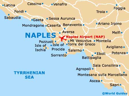
Naples Airport (NAP)
Orientation and Maps
(Naples, Italy)
The capital city of Italy's Campania region, Naples (Napoli) is a much-visited destination and boasts a range of appealing sights and sounds. Located on the western coastline, Naples is less than three hours' drive from Rome, which is situated to the north-west.
Other important points of interest close to Naples include Napoli Capodichino Airport (NAP), Pozzuoli to the west, and Torre del Grevo to the south-east. The Parco Nazionale del Vesuvio (Vesuvius National Park) is situated to the east and based around the famous Mount Vesuvius volcano, covering a vast area of around 135 square kilometres / 51 square miles.
Naples Capodichino International Airport (NAP) Maps: Important City Districts
The best way to get around in the centre of Naples is to walk. The old part of the city is based around the Via Toledo and the Piazza Garibaldi, and is known locally in Naples as the 'centro storico'. This is a particularly lively part of the city and the streets are regularly full of crowds and general hustle and bustle.
For a quieter part of the city, head to the famous Bay of Naples, where you will find breathtaking views and many coastal attractions and seafood restaurants. The main artery of the city is the Via Toledo and stretches from the Palazzo Reale to the Capodimonte area, close to both the Chiaia and the Vómero districts.
Italy Map

Naples Map